[ad_1]
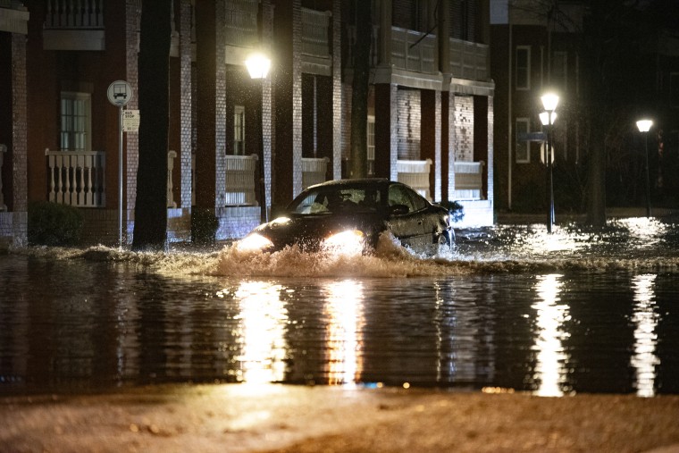
Torrential rain and flash flood warnings hit the Northeast early Wednesday, leaving more than a half-million customers without power at one point, while some areas forecast additional rain starting Friday.
By early Thursday, power remained out for more than 41,000 customers in New York state; more than 23,000 in Pennsylvania; and over 13,700 in New Jersey, according to the outage tracking website Poweroutage.us — much lower than the over 100,000 customers that had been without power in New York and Pennsylvania earlier.
Pictures shared on social media early Wednesday showed coastal areas of Maryland hit by flooding, with parts of Baltimore and Annapolis underwater as winds in parts of the state reached 80 mph.
Roads flooded up to doorways in parts of Long Island, the National Weather Service for New York City said, and business flooded.
What’s more, the bad weather — which has killed five people across the country this week — is not over for millions of Americans.
A winter storm will continue to impact the Midwest and Great Lakes into Friday, the weather service said. A winter weather advisory covered most of Nebraska and parts of Kansas early Thursday, and another large swath to the east was under a winter storm watch from Iowa to Michigan.
In the New York City region, forecasters warned: “You guessed it! Another strong storm system is expected to bring another round of rain, wind, and coastal flooding Friday night into Saturday.”
That could mean widespread 1 to 2 additional inches of rain, with more possible, the weather service said. A moderate river flood threat remained for Connecticut and New Jersey Thursday.
In New York City, LaGuardia Airport ordered a ground stop because of high winds overnight — meaning not a complete halt but longer delays between flights — but other New York airports remained fully operational.
New Jersey Gov. Phil Murphy announced a state of emergency in advance of the storm. In the Lodi area, an empty shipping contained that had been part of a nearly finished construction project was swept by floodwaters into a river, and hoisted out with a crane. It was so big that one person thought a tractor-trailer had been swept away, Murphy said.
“We’ll keep doing whatever we can. Obviously, our hearts are with the homeowners who are getting whacked with this,” Murphy said Wednesday after touring the damage.
Murphy said the rain was the third recent weather event in the last three weeks, and that it’s having a cumulative effect with soaked and saturated ground. More rain was expected Friday and next week, he said.
In New York, officials moved 1,900 migrants from temporary housing in a field in southern Brooklyn to a nearby school as winds reached over 70 mph, a City Hall spokesman said.

In Connecticut, homes and businesses along the Yantic River in Norwich were evacuated after a partial dam break, NBC Connecticut reported. A flash flood warning was issued until 6:45 p.m.
Residents in the area were told they may not be able to return to their homes and businesses for several days, according to the station.
Meanwhile, extreme winter weather continues for wide swaths of the country.
State troopers in Nebraska posted video on X showing them towing a stricken semi-trailer on a highway in blizzard conditions.
The weather service said in a storm warning Tuesday night that moderate to heavy snow would continue across parts of the Great Lakes, the Midwest and northern parts of New England, with a winter storm warning continuing for much of those regions.
Parts of Iowa got more than 15 inches of snow Tuesday, with temperatures in neighboring Nebraska reaching 7 degrees Fahrenheit. Snowfall of 6 to 12 inches was still possible Wednesday from the Great Lakes to northern New England, the agency said.
A low-pressure weather system engulfing much of the eastern half of the U.S. was expected to move into Quebec on Wednesday afternoon.
In western regions, a weather front moving inward from the Pacific on Wednesday was expected to bring “very heavy” snow to the Cascade Mountains and the Sierra Nevada.
The extreme weather is still not done for this week. A potent Arctic front will move south from Canada later Wednesday, bringing some of the coldest temperatures of the winter season so far for the northern Plains region, including possible subzero conditions in the Montana and the Dakotas, the weather service warned. A daily high temperature for Oklahoma is expected to be below zero by Friday, and the Arctic blast is expected to last beyond that.
 Latest Breaking News Online News Portal
